
Tuesday, April 23, 2013
Mystery of the Megaflood
We watched a movie called the mystery of the megaflood in lab and I found a summary of the movie from MSN Movies. It read, "Not so far back, an iconoclastic geologist began theorizing - in the face of hundreds of skeptics - that two million years ago, a titanic flood carved out the majority of present day Montana, Washington, Oregon and Idaho. His contemporaries turned their noses up and scoffed - until evidence surfaced to corroborate the scientist's theory: traces of an ancient ice dam alongside a Montana valley, which held in millions of gallons of water, until the dam itself melted - sending untold torrents across the Pacific Northwest and decimating everything in its path. NOVA: Mystery of The Megaflood, the acclaimed and multi-award winning WGBH series NOVA uses computer generated graphics to carry viewers into this ancient realm and study the enigmatic natural catastrophe that defined and sculpted broad vistas of our country. ~ Nathan Southern, Rovi”

Life Tables
We went to the Riverside Cemetery in Macon, Ga and collected data on people who died between 1917-1920 and another set of data on people that died 1960 between 1980 and created a life table for each.
1917-1920
1960-1980 life table:
1917-1920
|
X
|
X
|
X
|
X
|
Qx
|
|
0-1.9
|
5
|
0.178571429
|
1
|
0.178571429
|
|
2-9.9
|
3
|
0.107142857
|
0.821428571
|
0.130434783
|
|
10-19.9
|
4
|
0.142857143
|
0.714285714
|
0.2
|
|
20-29.9
|
2
|
0.071428571
|
0.642857143
|
0.111111111
|
|
30-39.9
|
3
|
0.107142857
|
0.535714286
|
0.2
|
|
40-49.9
|
2
|
0.071428571
|
0.464285714
|
0.153846154
|
|
50-59.9
|
2
|
0.071428571
|
0.392857143
|
0.181818182
|
|
60-69.9
|
3
|
0.107142857
|
0.285714286
|
0.375
|
|
70+
|
4
|
0.142857143
|
0.142857143
|
1
|
|
Total
|
28
|
1960-1980 life table:
X
|
Dx
|
dx
|
lx
|
Qx
|
|
0-1.9
|
5
|
0.12195122
|
1
|
0.12195122
|
|
2-9.9
|
4
|
0.097560976
|
0.87804878
|
0.111111111
|
|
10-19.9
|
3
|
0.073170732
|
0.780487805
|
0.09375
|
|
20-29.9
|
2
|
0.048780488
|
0.707317073
|
0.068965517
|
|
30-39.9
|
4
|
0.097560976
|
0.658536585
|
0.148148148
|
|
40-49.9
|
8
|
0.195121951
|
0.56097561
|
0.347826087
|
|
50-59.9
|
4
|
0.097560976
|
0.365853659
|
0.266666667
|
|
60-69.9
|
3
|
0.073170732
|
0.268292683
|
0.272727273
|
|
70+
|
8
|
0.195121951
|
0.195121951
|
1
|
|
total
|
41
|
Monday, April 22, 2013
Topography Map
A topographic map is a map that uses contour lines to describe elevation changes. Usually, they include bodies of water and other natural features.
Topographic maps are important because they are typically more accurate than a common map. They are also vital to engineers and architects to do their jobs.
This is a topographic map of Mount Blackburn in Alaska that I created using Google Earth:
Blue line is 5,000 ft
Red line is 5,000 ft
Green line is 6,000

Thursday, April 4, 2013
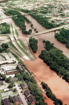
Flood of ‘94
In the beginning of July 1994, there was a flood in the central Georgia area. Some areas in georgia received 21 inches of rain. The levees of the Ocmulgee River breached and caused a lot of damage to the area. The flood ended up causing 18 people to lose their life. The flood also caused both interstates 75 and 16 to be closed off which had never happened before. The flood became known as the “killer flood” and Georgia had never seen anything like it. Statewide damage was estimated to be $58 million dollars not including business and residential damages.

In 1994 I lived in Warner Robins, Ga. I was only 2 years old but I remember hearing stories about the flood long after it happened. My parents said they took me to see the river a day before it flooded. Thankfully my house was not harmed by the flood.
Tuesday, March 5, 2013
A Perfect Storm
A Perfect Storm is a movie about a sword fishing boat that gets caught up in a disastrous “perfect storm” of 1991. The boat called Andrea Gail comes in to a port in Gloucester, Massachusetts. They did not successfully catch a lot of fish so in order to make up for the wasted trip the captain wants to quickly go back out to sea. This time he decides to go way out farther than anyone dared to go because the weather is known to be really bad but there are tons of fish. He decides it is worth it and he and his crew caught tons of fish. However they were not able to make it back with the fish because of a terrible storm.


A link where you can find this movie is at: http://www.gloucestertimes.com/andreagail
Thursday, February 7, 2013
Rocks and Minerals/Kruz Plaza
Minerals:
Quartz
Quartz is very abundant in the Earth’s crust. It occurs in almost all mineral environments and comes in a variety of colors. Quartz is about the most commonly known and abundant mineral. It tends to be somewhat brittle.
Granite

Granite is a type of igneous rock. They can be anywhere from pink to gray in color. Granite is widespread and a durable rock so it is used a lot in construction.

Granite is a type of igneous rock. They can be anywhere from pink to gray in color. Granite is widespread and a durable rock so it is used a lot in construction.
Kaolinite

Kaolinite is a clay mineral. The color is usually white to yellowish. In the southern rural areas it is not uncommon for people to eat kaoline for the mineral value and many other traditional reasons.
Mica

Micas are known for their extremely flaky rock characteristics, also known as cleavage. This mineral can be found all over the world. Mica is used in may household products including paint.
Cruz Plaza

There is currently a lot of construction going on at Mercer’s campus. The entire inner campus is being renovated which we be called Cruz Plaza. Over the course of the construction process, the contractors have to keep a few things in mind. First is safety. The construction crews must make sure they are being vert cautious because it is in the middle of a semester so there is a lot of traffic going in and out. Another thing to be addressed is the existing infrastructure. The contractors need to be careful not to damage any existing buildings or damage and lines or pipes running in the ground. Lastly, they have to deal with erosion and how to prevent it. They are putting out gravel and using other methods to minimize erosion when it rains.
Subscribe to:
Comments (Atom)